Archive for January, 2010
As an around-the-world traveler, you tend to hear a lot of the same questions: What are your favorite countries? How much does a trip like this cost? Where do you do your laundry? But every once in a while, you’ll get a query that really stops and makes you think. Do you become blasé about amazing sights because you see them every day?
Well shoot, that’s a good question. Do we?!?
I’ll admit that some of the places we’ve visited have not seemed as impressive as they would have had we visited under different circumstances. I’m sure I would have been blown away by Ephesus or Krabi or Xian had we visited straight from SF.
But we’ll get back to that in a second. For now, let’s cut to Ani, the former capital of Armenia. Ani is a site in eastern Turkey that is literally yards away from the Armenian border.

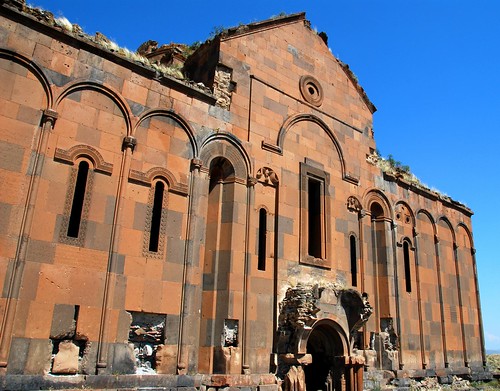
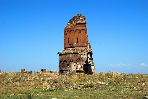
Cattle worshipping at the Church of St. Gregory in Ani.
The closest town to Ani is Kars and frankly, there is not much reason to go there except to visit Ani. A run-down, Soviet-style town, Kars is pretty far off Turkey’s beaten path…so much so that within an hour of getting off the bus, the guy who is mentioned in our Lonely Planet as a reliable guide finds us, along with pretty much every other tourist in Kars (there were 10 of us). Still, Kars grew on us, despite the dilapidated buildings and the uninteresting city plan (a Soviet-style grid).

Bird’s eye view of the Armenian-style church and mosque in Kars.
It’s a 1.5 hour long ride to Ani from Kars, and the 10 of us tourists hopped in a van to visit these Armenian ruins. Along the way, we got to know our fellow travelers: 4 older Brits, an American, a Spanish guy, and a couple from Switzerland. And despite the fact that Jeremy and I were a bit “ruined out” at this point in our Turkey travels, we were still excited to be visiting Armenian-style ruins that so few visitors to Turkey get to see (indeed, our bus contained the only visitors to Ani that day). We pay our 5 TL entrance fee and wander through the old city walls:
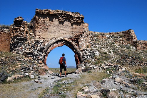
Jeremy framed by the old city walls.
And this is when the Spanish guy says:
“Ahhh! This is SHIT!”
Uh, excuse me, Spanish guy? Really?!? THIS is shit? Apparently our Spanish friend was a big photographer, and the lighting conditions at 11 AM were unacceptable to him. The first 10 minutes of our visit to Ani was narrated by Mr. Wet Blanket: “This isn’t Ani! You should look on Flickr if you want to see real pictures of Ani! I should have come at sunset!”
Quickly deciding that the Spanish guy was harshing our buzz, Jeremy and I lost him and wandered around Ani’s vast, empty grass plains on our own.
It really was a beautiful place. The cows grazing in the fields, the rugged valleys, the intricate stonework, and the panoramic views to Armenia…all of it colluded to make us believe that Ani was somehow magical.
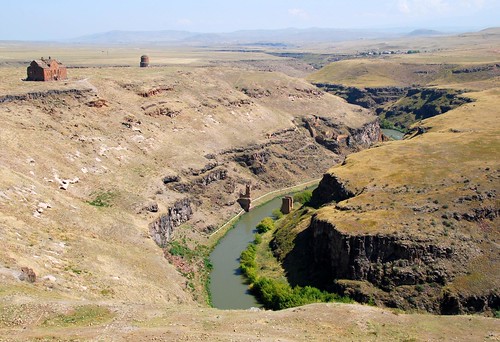
Turkey on the left, Armenia on the right (separated by the Araks River).

Hope framed in the doorway of the Ani Cathedral.
And to answer your question: No, I don’t think we’ve become blasé about amazing sights.
Transportation from Ayder to Kars: First, the bad news: our first bus driver stuffed about 25 people in a van made to seat 15, we had no idea if we would actually make it to Kars due to the language barrier, and our third bus broke down in the middle of nowhere. Twice. Now for the good news: the trip from Ayder to Kars was the most breathtaking bus ride we’ve taken so far on the trip. We traveled from the lush greenery of the Kaçkars’ Black Sea side to the dry, rocky landscape of the south side. And then it was on through verdant pasture lands, mountains with ramshackle stone houses built into their sides, little boys herding cattle through dry, golden steppes, and whole families riding home in donkey carts after a day of working in the field.
Due to MASSIVE CONFUSION as a result of the language barrier in this region, we have no idea how to advise you on getting from Ayder to Kars. Just know that (1) you can do it (we didn’t even know that much before we got on the bus), and (2) it will cost you 55 TL (US$35) each for the entire trip.
Where we slept in Kars: Though the Güngören Hotel (50 TL or US$30 for a double ensuite) is pretty rough around the edges, so is the rest of Kars. It’s not much to look at, but the rooms are pretty big and the staff is nice.
If you’ve been following along, you know by now that Turkey has got it all: a wandering coastline bordering lucid blue waters, a cosmopolitan city wrapped around a chewy historical center, snowy white rock springs so lovely that visitors are moved to strip down to their Speedos (in a Muslim country no less), and a surrealist landscape that would make Dali proud. We saw all these amazing sights in west and central Turkey, so it was time to move to the northeastern corner of the country to check out some good, old-fashioned mountains.
The Kaçkar Mountain Range is a famous trekking area in Turkey. However, Turkish trails, especially in this region, are notorious for being badly signposted. We were strongly advised to find a guide, even for a day hike. But when Jeremy and I researched 3- and 4- day treks through the Kaçkars, we found them to be prohibitively expensive—often over €600 per person! Figuring we would have better luck finding a decently-priced guide once we arrived in the Kaçkars (after all, companies who advertise on the internet are often more spendy), we put ourselves on a bus headed northeast (for more on that saga, read the Transportation section below) and crossed our fingers. The eastern side of Turkey is much less touristed, and information on the area is either scarce or outdated. But everything has always worked out before…why should this time be different? (And this is the point in the movie where you would be screaming, “No! Don’t walk through the door! There’s a monster hiding in there!!!”)
There are two ways you can approach the mountain: on the Black Sea side (in which case a little town named Ayder would be your home base), or via the southern side of the mountain (Yusufeli). Our guide book recommended Ayder as a good place to organize treks, and we had no reason to doubt the LP’s accuracy. (MONSTER!!!!)
We reached Ayder exhausted, hungry, and delirious (17 hours of bus rides will do that to you). And then there was The Hill. See, Ayder’s bus stop sits at the bottom of a long, steep hill…and naturally all the guest houses are a several huffs and puffs from the station.
We were in for more surprises. First of all, Ayder was dead. We could barely find a soul on the street, much less someone to take us up the mountain. Of the few people who we could find, no one spoke English. How exactly are we supposed to find someone to take us hiking?
We literally wandered all over the town of Ayder, trudging up and down the hill, from one place to the next, pantomiming our desire for a mountain guide. After a couple of hours of this, we had downgraded our expectations from “multi-day trek” to “day hike.” Tired, hungry, and frustrated, we gave up for the day and stopped into the closest restaurant for dinner, hoping our hiking plans would miraculously work themselves out by morning. And what do you know? Not only did we find a very sweet family serving amazing home-cooked food, but even better—a couple of Israeli tourists stopped in after completing a 3-day trek and we peppered them with questions about hiking in the Kaçkars. From this we gathered: catch the 10AM bus to Kavrun and organize a trek from there. Success!!!
After a few false starts (the bus leaves at 10AM, no—9AM, no—9:30. Ish.), we take an hour and a half to arrive in Kavrun, even though it is only 30 km away (blame the terrible roads…and the tea stop). This gave us plenty of time to meet other English-speaking travelers on the bus: a German couple, and two Turkish guys.
It’s true: you can find a guide in Kavrun. The Turkish guys got to work trying to negotiate a price for a guide to take all 4 of us up the mountain (the Germans opted out of the hike), but when that price is deemed too high, we decide that we can find our way as a group. What could possibly go wrong with this plan? (The monster—he’s right behind you!!!!)
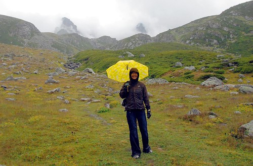
Long story short: about 3 hours into our trek, the weather turned bad. As in, really bad. As in, rain + fog + thunder + lightning + hail kind of bad. So bad you can’t see 10 feet in front of you kind of bad.

The town of Kavrun, enveloped in fog. This photo was taken 2 minutes after the photo above.
Jeremy and I decided to turn around, but the Turkish guys stubbornly decided to keep looking for our final destination (a group of alpine lakes). Ten minutes after we left them, Jeremy and I found the lakes. Our group had walked right by them on the way up, but the thick fog obscured our view.

How could we possibly miss this?!?
After a few scary moments of losing the trail in severe weather, J and I finally found the original path and booked it down the mountain as fast as we could. We were cold and soaked to the bone, but we were happy with our decision to turn around.
We finally made it back to Kavrun’s little cafe and joined a group of Israelis and the German couple warming themselves by the fire. And here’s where the story really gets interesting. Turns out the bus driver was waiting for the 4 of us to return from our hike before he was willing to make the drive back to Ayder (perhaps he communicated this to the Turks, but J and I had no idea). The Israelis and Germans had been waiting ALL DAY for us, and were understandably upset about this. But given that this was the only bus back to Ayder, we didn’t want to leave the Turkish guys on the mountain. They weren’t properly dressed and the weather was really bad. So we waited.
And waited.
And waited.
And then we worried. Well, at least Jeremy and I worried. Everyone else was pissed off and wanted to get going. But the bus driver stuck to his guns—he wasn’t going to leave the two Turkish guys stranded in Kavrun without a ride back to Ayder.
More waiting.
Finally, one of the Israeli girls harasses the bus driver long enough that he agrees to leave. We ask the guides at the cafe to go looking for the Turks if they don’t show up before 5PM. On our way out, J and I kept looking out the windows, searching for our lost Turkish friends. We hope they made it back safe.
Transportation from Cappadocia to Ayder: Despite warnings from the bus ticket vendor (we thought he was just trying to close the sale), J and I wait until the day of to buy tickets from Cappadocia to Ayder and find that they are sold out. Note to future travelers of this route: Buy your tickets several days in advance! This is a not a heavily traveled route—there are only 2 bus companies that make the trip each day.
We also found that the Lonely Planet has either outdated or incomplete information on this region. The guidebook said there were direct buses from Rize to Ayder, but after an exhausting overnight bus ride from Cappadocia to Rize, we found (after much pantomiming) that we had to take a local bus to the Rize minibus terminal, catch another bus to Pazar, where we could catch a direct bus to Ayder. Since our original bus from Cappadocia was headed further east, life would have been a lot easier if we just got off the bus in Pazar rather than Rize. Another note to future travelers: don’t blindly trust the Lonely Planet! Always double check the info you get from your guidebook, especially in “off-the-beaten-path” destinations. It could save you a lot of pain and frustration.
All of this travel was during Ramazan. So prior to getting on the bus to Pazar, we bought a kebap, and then proceeded to try to eat said kebap on the bus without any of the locals seeing (it’s rude to eat in front of fasting Muslims). I have never in my life felt so guilty for eating a sandwich.
Where we slept in Ayder: We found a cheap (50 TL for double ensuite), comfortable little family-run place about 2/3 up the hill in Ayder, called something like Uçhisar or Uçhalar Pensiyon (sorry, notes are thin for this region). Can’t say I recommend the place, as the showers were not hot. There’s nothing like taking a lukewarm shower after getting drenched in the Kaçkars. Can’t say I recommend that, either.
It’s not often that party banter will bring you half way around the world. Before we left on our trip, we met a California surfer at a party, and after finding out he had been to Turkey several times, we asked the obvious question: “What we shouldn’t miss in Turkey?” His answer:
“Cappadocia, dude.”
Even with this glowing recommendation, and even though Cappadocia is so stunningly weird that it is featured on our guidebook’s cover, we still weren’t prepared for the sheer surreality of the landscape.
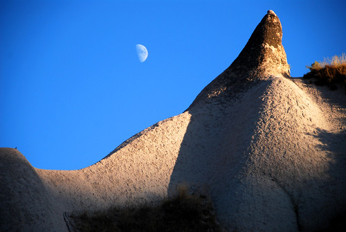
Cappadocia (which is actually a very large region in Central Turkey, though most people only visit the 60 radius miles or so around a town called Göreme) is known primarily for its unique rock formations called “fairy chimneys,” which come in all shapes and sizes. Some look like teepees, some look like mushrooms, some look like little guys wearing hats, and others look like…um, asparagus (or something more X-rated if you are of that persuasion). But like a bottle of wine that you buy because you like the label, only to be pleasantly surprised to find that it actually tastes decent, Cappadocia is more than it seems on the surface. Sure, the multi-colored landscape is incredible, but there are many more sights and activities in this region to sustain a traveler for the better part of a week.
But you gotta start somewhere, right? So let’s start with judging this book by its cover.
Fairy Chimneys and Rock Houses
Cappadocia’s natural beauty is impressive enough as it is, but take that Dali-esque environment, throw some humans into the mix, and that’s when things really get weird. Believe me, I like my nature as unspoilt as the next traveler, but I think Cappadocia’s landscape is fascinating because of the way ingenious locals have altered and interacted with their environment. The volcanic rock that comprises Cappadocia’s fairy chimneys is soft enough to be carved, yet it hardens when it comes in contact with air, so that the interior of these tent-shaped structures can be sculpted into rooms, stairs, and windows—ancient pre-fab homes!
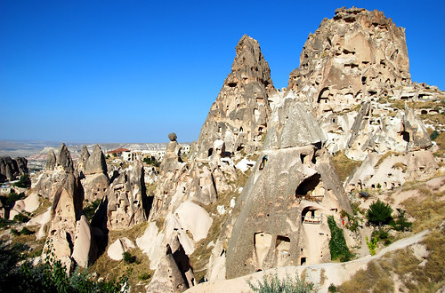
Uchisar Castle surrounded by rock houses.
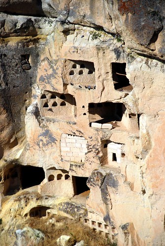
Rooms cut into the side of a cliff. The small arched coves are dovecotes. The people of Cappadocia were agricultural, and they gathered pigeon guano for use as fertilizer.
And why would you stop at building houses? In Göreme’s Open Air Museum and Soğanlı Valley (which we reached via scooter after failing to realize that it was more than 50 miles from Göreme, much to the chagrin of our butts), you can wander through rock-cut churches covered in colorful murals. Unfortunately, some of the murals have been damaged by ancient graffiti cut into the rock. We saw names carved with dates as far back as the early 1800s! I guess disrespect is timeless.
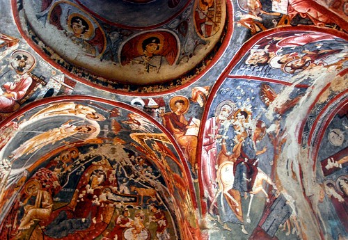
Interior ceiling of one of the rock churches in Göreme’s Open Air Museum.
How’s the view?
It’s all about the view in Cappadocia. A popular thing to do in this region is to take a sunrise hot-air balloon ride, but at €250 per person, this just wasn’t in our budget. We were happy to save our dough and watch from the roof of our pension as the balloons glided silently over Göreme.
Lucky for all of us who can’t afford a €250 per person balloon ride, there are plenty of places to catch a breathtaking view in Cappadocia. The most popular viewpoint is from atop Uçhisar Castle:
Our favorite viewpoint was discovered by accident, when we climbed to the top of Cavuşin Old Village. Unbelievably, this place is not mentioned in the Lonely Planet!

Hiking down the back side of Cavuşin Old Village.
The sunset spot in Ortahisar (entry fee=1 TL) ain’t too shabby either, though it is only accessible via car (or scooter). For those on foot, there’s always the sunset spot in town.
Let’s take it down a notch
Not only does Cappadocia have a lot going for it on land, but below, too! In order to hide from persecuting Romans, early Christians carved out underground cities with up to 8 levels, with ingenious air shafts that allowed ventilation. Our favorite feature of these underground cities were the rolling doors, which sealed off crucial passageways in the event of an attack. These doors have a small hole carved out of the middle of the wheel—just big enough to fit a spear intended for any invading Romans.

A rolling door in Derinkuyu underground city.
There are several underground cities in Cappadocia, but we visited Derinkuyu because it is the one underground city that the tour buses don’t visit. Unfortunately, we failed to realize that a lack of tour buses also meant a lack of tour guides (many other travelers strongly advised hiring a guide because they can make the underground cities come alive). I was just starting to get bummed out about our guidelessness when a local boy and his friend introduced themselves to us and started leading us on their own informal tour. We crawled in and out of passageways (underground cities are not for the claustrophobic) with these two Turkish teens, and even though they only spoke basic English, we had a waaaay better time exploring with the two of them than on any stinkin’ tour!

Jeremy posing with our Derinkuyu tour guides.
At the end of our informal tour, our wary “travelers’ shells” had us anticipating a tip request, but it never came. Which brings me to my next point:
Cappadocian people are awesome
Cappadocia taught us that a friendship could be formed by something as simple as a sneeze. Picture it: we’re walking down the main street in Göreme, when Jeremy sneezes so hard his backpack flies off. A bunch of listless Turkish men suddenly start laughing and a tall, handsome local man with a big gap-toothed smile approaches to invite us into his bakery. He offers us free baklava, with the following explanation:
“It’s not easy to make a Turkish man laugh during Ramazan!”
And this is how we came to meet the best baklava we’ve ever tasted: not too sweet, not too soggy, and not too crispy. Just pure honey-soaked, flaky goodness. After “The Sneeze Heard ‘Round Göreme”, our friend at Nazar Börek always greeted us with his big, gap-toothed smile, and we always stopped to chat with him and eat a few pieces of his baklava. And it all started with that sneeze.
Traveling through surreal lands
Hiking is another big draw in Cappadocia. There are several trails close to Göreme that take you through valleys with abandoned rock houses, though the majority of the hikes (with the exception of the Rose and Red Valley trails) are very confusing and badly (if at all) signposted. Note to Turkish entrepreneurs: someone could make a killing off an accurate trail map.
Our favorite hike was recommended by none other than our baklava friend. There is some confusion as to the name of this trail, as it was called Pigeon Valley on one map and Love Valley on another—just know that it is the valley linking Uçhisar and Göreme. Despite the fact that it is a very difficult trail to find, it’s a winner!

Our favorite hike in Cappadocia.
In conclusion, Cappadocia has it all: amazing landscape, incredible people, great baklava, interesting historical sites, and nice outdoor walks. It took us 8 months and who knows how many thousands of miles to realize that the California surfer said it all. Cappadocia, dude.
Transport from Antalya to Cappadocia: There are several buses each day from Antalya to Cappadocia, though most of them are night buses. Ignoring the fact that it sucks to sleep on a bus, we prefer day buses because you get to see so much of the country. Some people might argue that you lose a day traveling, but we feel like you gain a better understanding of the landscape when you bus during the day. It’s a 10 hour ride from Antalya to Cappadocia, and on Metro Bus, the trip’s a cool 70 TL (US$23) each.
Where we slept in Cappadocia: We’re pretty convinced that we found the hostel with the best view in Göreme. Kookaburra Pension is run by a crazy (in a good way), sweet (see “Cappadocian people are awesome”), funny guy named Ihsan. The rooms have a homey feeling and the view on the upper deck is spectacular. At 60 TL (US$38) for a double ensuite, it’s not the cheapest place in town, but it might just be the best.

