Posts Tagged ‘Queenstown & Wanaka’
Every single one of our friends who has been to New Zealand told us that Wanaka was amazing, and they were right. Though the weather was not ideal when we were in the area, we still fully enjoyed the amazing landscape that we have come to expect from this magical country.
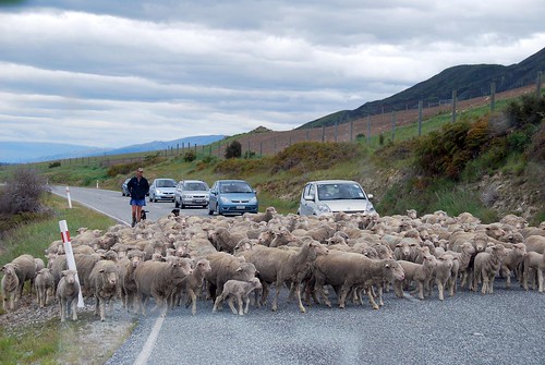
But first…sheep crossing!!!
Wanaka
The Wanaka landscape is dominated by two absolutely enormous lakes: Lake Hawea and Lake Wanaka. We saw Lake Hawea on our drive in, but didn’t really spend much time there except to snap a few photos of the view.
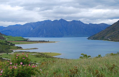
Lake Hawea.
Our exploration of this area started with a hike up Mt. Roy, overlooking Lake Wanaka and the city. The hike started off in private farmland where there were sheep nursing their young lambs and the trail was (thankfully) nice and grassy (spongy and easy on the feet!).
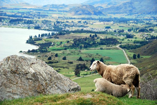
I want num-nums!!! Overlooking Lake Wanaka and the town of Wanaka…
Eventually we crossed over into public land where the landscape changed pretty drastically and there were large tufts of mustard-colored native grasses dotting the trail.
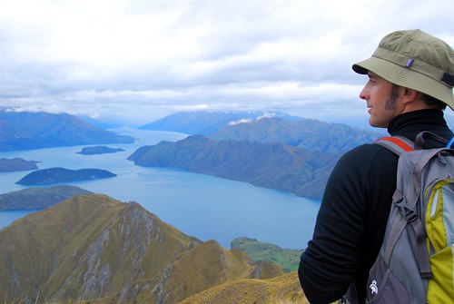
Jeremy overlooking Lake Wanaka.
OK, if it looks like we’re pretty high up in the above picture, that’s because we were. This was the biggest hike we had done in NZ. The trail markers estimated the return hike at 5 hours, and as we’ve mentioned before, Kiwi trail estimates are extremely accurate. It was a sustained 3 hour hike straight up a steep hill. The ascent wasn’t so bad, actually—it was the downhill that really made it’s mark. That is a solid 2 hours going downhill…our knees, quads, and booties really paid the price for that little excursion.
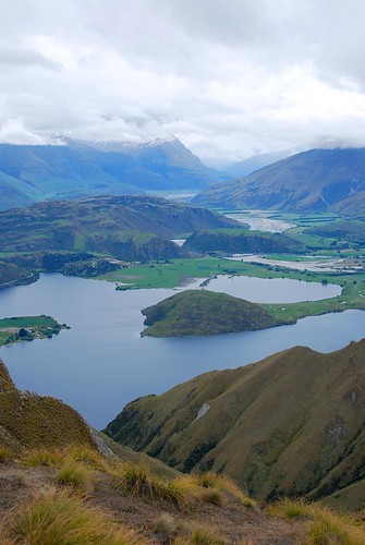
At the summit overlooking Diamond Lake.
Mt. Aspiring National Park
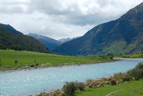
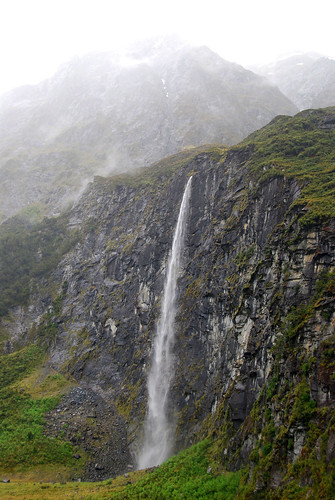
The following day we drove into Mt. Aspiring National Park, about an hour from Wanaka. We heard about a nice hike there to Rob Roy glacier (Kiwis and their glaciers!). The hike started off along a beautiful river…
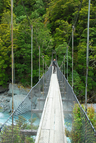
…and then you cross a swing bridge…
…and hike for about 2 hours until you hit this:
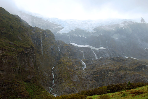
Unfortunately, the weather turned kinda sour when we hit the end of the trail, and we were rained on pretty heavily during the return to the car. It wasn’t so bad, actually…it was kinda fun! There were a lot of waterfalls in the mountains as a result of the weather and it made for a pretty scenic hike back to the car.
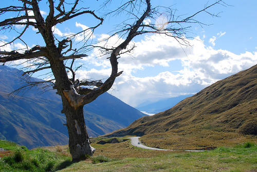
Of course, as soon as we got out of the national park, the sun was shining as bright as could be, which made for a breathtaking drive into Queenstown:
We stayed in Queenstown just long enough to see a bit of the town and buy groceries for the night…this is the most heavily touristed place in the south island we were told by a couple of people to avoid it. Queenstown is known as the “Xtreme sports capital” and there are bungy jump centers all over the town centre. As a result, we had pretty low expectations of the place, but what people failed to mention was how incredibly gorgeous the area is. Nestled at the base of The Remarkables (a mountain range that offers skiing in the winter), Queenstown and it’s bordering Lake Wakatipu are absolutely stunning. Still, it does have the feel of a resort town so we didn’t mind spending only a few hours in the area.
Wanaka is an amazing place and this is the one area on the south island where we wish we could have stayed a little longer. I guess it will have to wait for our next visit to NZ?
Thanksgiving at Four Rivers
When we finished our tramp through the hills above the Nelson Lakes, we packed up the van and followed the river towards the West coast for a few hours and found a holiday park near Murchison to camp for the night. Surprise, surprise…another gorgeous camp with a cafe overlooking the river.
We shared the camp with a group of teenagers from the US and Canada who are part of a “Kayak Academy”. They travel around the world (or at least New Zealand and Chile) with their instructors/coaches, do schoolwork in the morning, and kayak in the afternoon. Not a bad life, if you ask me—and gives me some ideas for how to get more involved with our kids’ education. I tried (but probably failed) to impress one of them with stories of growing up kayaking in Idaho. Sheesh, kids these days…
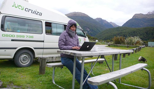
We Skyped Hope’s parents from the van to wish them a happy Thanksgiving and then got to work preparing our own celebratory meal. They don’t seem to have turkey in New Zealand, so we had to settle for pan-fried lamb chops with fresh thyme, rosemary, and garlic and a cucumber salad with feta cheese. We didn’t miss the bird.
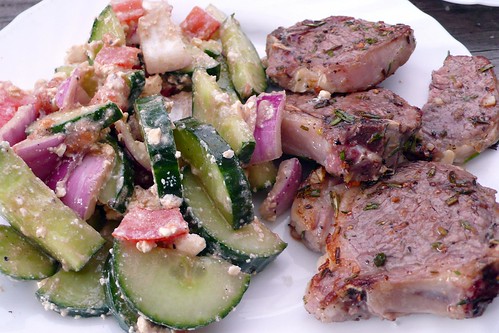
Our Thanksgiving dinner.
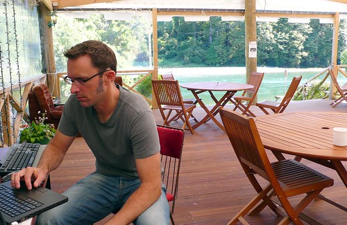
Getting ready to Skype Jeremy’s parents from the cafe at the Murchison Holiday Park.
Westport and Cape Foulwind
The next morning, we headed west towards the coast. We stopped at the Bay Cafe in Tauranga Bay (one of the recommended stops on Bob’s Tour) and had a delicious curried seafood chowder and some fresh baked garlic bread.
Pancake Rocks (at Punakaiki)
On the way down the coast, we stopped for an hour at Pancake Rocks, an area where layered limestone has been exposed and carved away into intricate shapes by the waves. At high tide, there are blowholes that funnel the crashing waves into water spouts. Apparently, geologists don’t understand how the unusual layered limestone was formed, but they sure look cool. The New Zealand park service did an excellent job providing access to the site: the trail was lined and camouflaged with limestone bricks meanders through the rock formations, providing safe (for tourists and the rock) and easy access to the sites without making the whole thing feel too packaged. Pancake Rocks probably don’t warrant a special trip, but definitely worth a stop if you are driving by. Unfortunately, we arrived too late to try the blueberry pancakes at the nearby cafe.
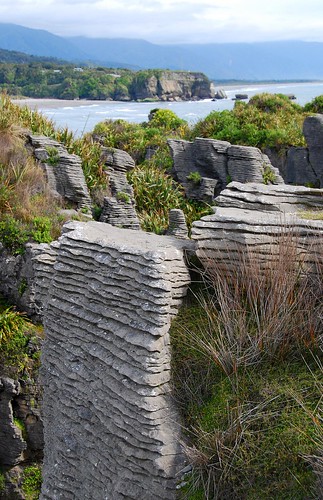
Pancake Rocks
Franz Josef Glacier
The Franz Joseph and Fox glaciers are one of the big tourist attractions on the West coast. According to one of the signs, they are the only glaciers in the world that descend into rainforest (but I need to check on that because we have subsequently seen other glaciers in New Zealand that also appear to descend into rainforest).
We stopped that the i-Site (nearly every town and tourist destination in New Zealand has one of these typically very useful information centers) in Franz Josef to figure out a hike to do. The woman warned us that the trails to the glacier had been washed away by the recent rain storms and that we would not be able to hike all the way to the glacier. But, like about half the other hikers out that day, we ignored the trail closed signs, hopped from rock to rock across the river and walked up the moraine to the foot of the glacier. We were careful to not get too close: the glacier was clearly “in retreat” (global warming at work) and large chunks of rock and ice were peeling off the front edge every few minutes—we could feel the thud through the ground when they hit. The information center had prominently displayed a recent newspaper story about the “incredibly stupid” tourists who had ventured into some of the caves in the front of the glacier and been trapped by falling ice, nearly killing themselves and the guides that came to rescue them.
As an indicator of the effects of climate change in this area, In 1900, the river bed (or more accurately, glacial moraine) leading up to the glacier was covered by 100 meters of ice. At the trailhead, there was a picture taken in the late 1800’s of a couple rowing a boat around the lake that used to form seasonally in front of the glacier.
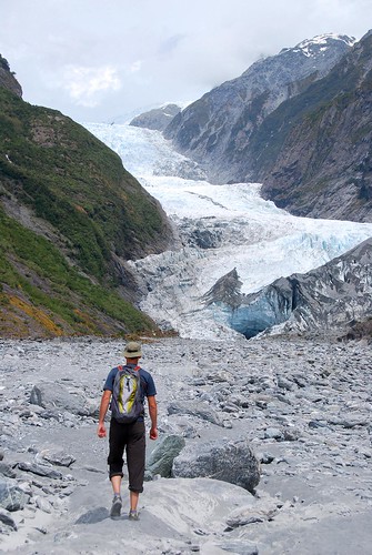
Walking up the moraine.
Haast Pass
Just a couple more hours south is Haast, the last town on the West coast. We had heard horror stories about the sand flies at Haast, so we made just a quick stop before heading inland. A couple of hours later we made it to the pass that separates the West coast from the Wanaka region. We found a camp site near Makarora at dusk and prepared dinner. We mostly finished dinner and were washing up when the flies came out. Several dozen managed to get into the van before we got all the doors and windows closed. Hope spent the next hour on a murderous rampage with the now blood-stained road atlas. She managed to smash every last one and we had a peaceful night sleep. We subsequently discovered a better weapon to against bugs in the van: a wet paper towel. You just need to touch them and their wings stick to the wet fibers: much less work and not nearly as messy. We have heard that the sand flies can be bad all over the South Island, but we only had a problem here and one other place.
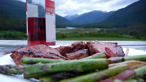
Steak and asparagus, mmmmmmmm….
Beautiful, until the sun sets and the sand flies come out to feed.
ABOUT
Hope is 5 foot 11. Jeremy is 6 foot 4. Together we are 12FOOT3. This is our around-the-world travel blog. Come see the world from our point of view.